 Shelbyville Wx
A Climatology of Shelbyville
While there is no “official” observation site in Shelbyville, climate/normal data for the area has been developed through PRISM. PRISM uses data from across the United States to create a gridded climatology (read more about PRISM ). Using this data, we can get a decent idea about the climatology of Shelbyville.
Precipitation
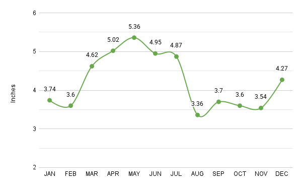
Shelbyville, KY PRISM Precipitation Normals (in)
Key highlights:
- May is the wettest month, with 5.36 inches of rain on average, perfect for spring blooms but watch for muddy fields!
- August is the driest, with just 3.36 inches, ideal for outdoor events.
- Spring (March–May) brings the most rain, while late summer and fall (August–October) are the driest times of year.
Temperatures
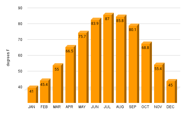
Shelbyville, KY PRISM High Temperature Normals (F)
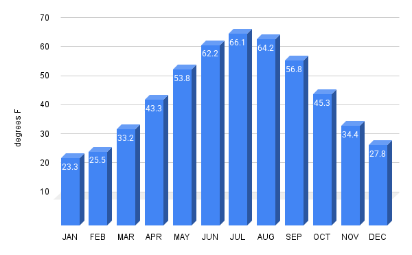
Shelbyville, KY PRISM Low Temperature Normals (F)
Key Highlights:
- July is the hottest month, with average highs of 87°F and lows around 66°F, great for summer barbecues.
- January is the coldest, with highs near 41°F and lows dipping to 23°F, bundle up!
- The warmest day of the year is typically July 21, with an average temperature of 66.68F, while January 23 is the chilliest, with an average temperature of 30.66F.
Snowfall and Extreme Weather
While snowfall normals are not calculated by PRISM, official climatological snowfall sites in Louisville average 13.4” and Lexington 14.5” per year (this data comes from the National Weather Service).
Shelbyville made history on January 19, 1994, when the temperature plummeted to a bone-chilling -37°F, the coldest ever recorded in Kentucky. This followed a massive snowstorm that blanketed the region, shutting down schools and roads. Read more about this frigid day at the WLEX website.